Sierra Nevada Road Closures: Why I-80 is Halted
Snowfall accumulation and low visibility lead to major trans-Sierra travel restrictions and mandatory chain requirements on April 12, 2026.
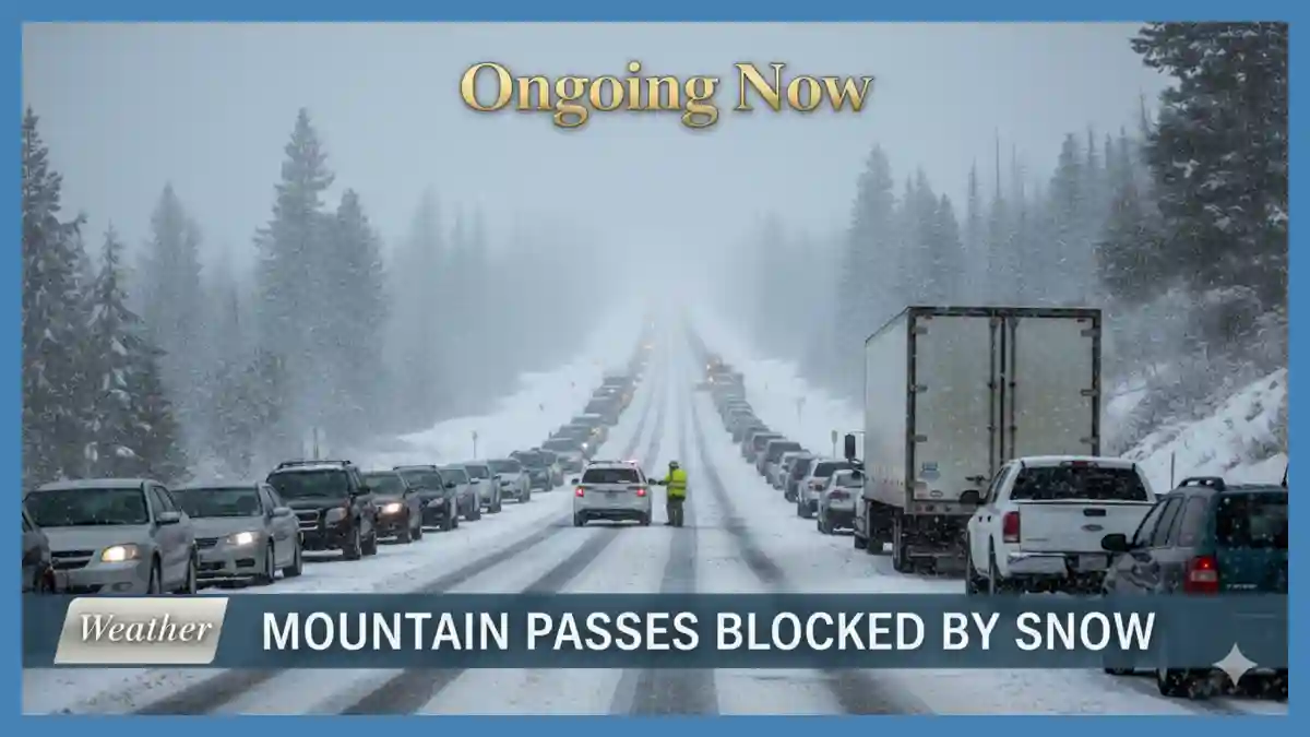
A significant spring weather system moving through Northern California has resulted in widespread Sierra Nevada road closures today, including a full westbound stoppage on Interstate 80 from Colfax to the Nevada state line. Current I-80 snow conditions live reports indicate near-zero visibility and heavy accumulation, prompting Caltrans to issue hazardous mountain driving alerts for all major trans-Sierra routes. Motorists should be aware of stringent Tahoe chain requirements on Highway 50 and Highway 88, while several high-elevation routes like Sonora Pass (SR-108) and Monitor Pass (SR-89) remain closed for the winter season. The NWS storm warning updates project an additional 12 to 24 inches of snow across the range through Monday morning, directly impacting mountain pass weather updates and shifting ski resort opening status toward extended spring operations.
The National Weather Service (NWS) and the California Department of Transportation (Caltrans) are actively monitoring a deepening low-pressure trough originating from the Gulf of Alaska. According to the Center for Western Weather and Water Extremes (CW3E), this system is interacting with a cutoff low to produce moderate-to-heavy snowfall at elevations as low as 5,000 feet. Meteorologists from NWS Reno and NWS Sacramento have characterized this as a “moderate to major winter storm event” for mid-April.
Current Status of Sierra Nevada Road Closures Today
As of the morning of April 12, 2026, the primary artery across the northern Sierra, Interstate 80, is facing severe disruptions. Caltrans District 3 confirmed that westbound traffic is held at the Nevada state line due to unsafe driving conditions and spin-outs. This closure is part of a broader network of Sierra Nevada road closures today designed to prevent motorists from becoming stranded in high-elevation passes where snow rates are exceeding two inches per hour.
In addition to I-80, the Caltrans Highway 50 status indicates that while the road remains open, travel is significantly slowed by mandatory chain controls. Maintenance crews are working continuously to clear the roadway, but officials advise against non-essential travel until the peak of the storm passes. Smaller state routes, including SR-89 over Monitor Pass, were preemptively closed on Friday, April 10, in anticipation of this weekend’s precipitation.
Analysis: Why This Storm Impacts Travel
The timing of this system is particularly impactful due to the “spring transition” nature of the snow. Unlike mid-winter “dry” snow, April systems often produce “Sierra Cement”—heavy, wet snow that clings to trees and power lines and creates exceptionally slick road surfaces. This increases the risk of traction loss, even for vehicles equipped with standard winter tires, necessitating the strict enforcement of Tahoe chain requirements.
Key Forecast Data and Roadway Restrictions
The following table summarizes the current restrictions and projected conditions for major Sierra Nevada corridors as of April 12, 2026.
| Route | Status | Requirement | Forecasted Snow (High Peaks) |
| Interstate 80 | Westbound Closed (Colfax to NV Line) | Chains Required Eastbound | 18–30 inches |
| Highway 50 | Open with Delays | Chains Required (Kyburz to Meyers) | 12–24 inches |
| Highway 88 | Open | Chains Required (Cook’s Station to Picketts) | 15–28 inches |
| SR-108 (Sonora) | Seasonal Closure | Closed | N/A |
| SR-89 (Monitor) | Temporary Closure | Closed | 10–18 inches |
Note: Conditions are subject to rapid change. Motorists should check the Caltrans QuickMap app for real-time updates.
Understanding I-80 Snow Conditions Live
The I-80 snow conditions live feed currently highlights a “Level 2” or “Level 3” chain requirement across the summit. Under these conditions, all vehicles—including those with four-wheel drive—must carry chains, and those without four-wheel drive must have them installed. The closure at Colfax is a standard safety protocol used by the California Highway Patrol (CHP) when the number of vehicle incidents on the mountain exceeds the capacity of emergency responders to manage them safely.
Meteorological data from the Weather Prediction Center (WPC) shows that freezing levels have dropped from 9,000 feet on Friday to approximately 5,000 feet today. This shift has turned what began as a rain event into a significant snow producer for the foothills and mountain passes. The rapid accumulation on the pavement, combined with gusty winds reaching 45 mph, has created “whiteout” conditions at Donner Summit.
NWS Storm Warning Updates and Snow Totals
The winter storm warning California remains in effect through 5:00 AM PT on Monday, April 13. According to the NWS, the heaviest snowfall is expected during the afternoon and evening hours of Sunday. While the Sierra snow totals 2026 started below average in early January, this series of April storms has significantly bolstered the snowpack, which is vital for the state’s summer water supply.
“We are looking at a classic cold-core system that is over-performing in terms of snowfall rates,” says an NWS lead forecaster in the latest technical discussion. “Travel over the Sierra will remain hazardous through the end of the weekend, with total accumulations at the highest peaks potentially exceeding 36 inches.”
These Sierra snow totals 2026 are being closely watched by hydrologists. The National Operational Hydrologic Remote Sensing Center (NOHRSC) reported that as of April 10, the area covered by snow in the Sierra Nevada was approximately 13.5%, a figure expected to rise sharply following this weekend’s event.
Impact on Ski Resort Opening Status
For winter sports enthusiasts, the fresh powder has had a positive impact on the ski resort opening status across the Tahoe Basin. Resorts such as Palisades Tahoe, Northstar, and Heavenly have reported significant new arrivals, with some reporting over 15 inches in the last 24 hours. Many resorts that typically begin winding down operations in mid-April are now evaluating extensions into May.
However, the same snow that benefits the slopes creates a logistical challenge for the resorts. High winds often lead to “wind hold” on upper-mountain lifts, and the hazardous mountain driving alerts make it difficult for staff and guests to reach the mountains. Visitors are encouraged to check individual resort websites for “operation-day” updates, as many may have delayed starts to allow for avalanche mitigation and lift de-icing.
Safety and Preparedness: Navigating Hazardous Mountain Driving Alerts
When hazardous mountain driving alerts are issued, the most effective safety measure is to delay travel. If travel is unavoidable, the following preparedness steps are recommended by the National Weather Service:
Check Chain Requirements: Ensure you have the correct size chains for your tires and practice installing them before you reach the mountain.
Emergency Kit: Carry a “winter kit” including blankets, water, non-perishable food, a flashlight, and a full tank of fuel.
Slow Down: Speed limits are significantly reduced during chain controls. Hydroplaning and sliding can occur even at low speeds on slushy mountain roads.
Stay with Your Vehicle: If you become stuck, stay in your car. It is your best shelter against the elements and makes it easier for rescuers to find you.
Historical Comparisons and Climate Context
This April storm follows a pattern of “late-season surges” observed in recent years. While the bulk of California’s precipitation typically occurs between December and March, high-latitude troughs like the current one can deliver substantial moisture well into spring. Compared to the historical average, this event is notable for its low snow levels, which are more typical of February than mid-April.
Climate researchers note that while the frequency of these storms can vary, the intensity of individual events is often enhanced by warmer ocean temperatures in the Pacific, which provide more moisture for the atmosphere to hold. This leads to a “feast or famine” cycle where long dry spells are interrupted by intense, heavy-precipitation events.
Evidence-Based Weather Insights
The current atmospheric setup involves a “phasing” of two distinct low-pressure systems. The initial cutoff low provided the moisture, while the secondary trough from the Gulf of Alaska provided the cold air and “dynamical forcing” (the lift needed to create heavy precipitation). This combination is why the I-80 snow conditions live reports are so severe today.
Looking ahead, the European Centre for Medium-Range Weather Forecasts (ECMWF) and the Global Forecast System (GFS) models both suggest a drying trend starting late Monday. However, because of the volume of snow currently falling, the Sierra Nevada road closures today may persist into tomorrow as Caltrans works to clear the roads and stabilize slopes prone to sliding.
Stay sharp with Ongoing Now!
Source and Data Limitations: This report is based on data provided by Caltrans District 3 and 10, the National Weather Service (NWS) offices in Reno and Sacramento, and the Center for Western Weather and Water Extremes (CW3E). Road conditions are as of April 12, 2026, at 10:00 AM PT. Forecasts are subject to change based on the movement of the low-pressure system. Unverified social media reports regarding road “clearances” have been excluded in favor of official Caltrans QuickMap data. Regional variations in snow accumulation are expected due to the complex topography of the Sierra Nevada range.