Navigating the Invisible War: How GPS Spoofing Works in Aviation
Electronic warfare in the Middle East and Eastern Europe is creating unprecedented navigational challenges for civil aviation through sophisticated GNSS interference.
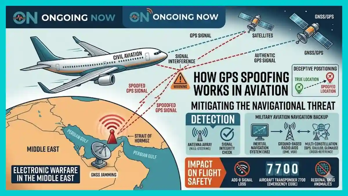
The aviation industry is currently facing an escalation in deliberate signal interference that compromises the integrity of satellite-based navigation systems. In regions such as the Strait of Hormuz and Eastern Europe, pilots are increasingly reporting instances where their onboard systems reflect false coordinates, a phenomenon known as GPS spoofing. This technique, distinct from simple jamming, involves the transmission of counterfeit signals that mimic legitimate satellite data but provide inaccurate positioning. As these incidents grow in frequency, the reliance on traditional military aviation navigation backup systems has moved from a contingency protocol to a daily operational necessity.
Global positioning is no longer a passive utility; it has become a contested layer of the digital atmosphere. Organizations like the European Union Aviation Safety Agency (EASA) and the International Civil Aviation Organization (ICAO) have heightened their monitoring of GNSS (Global Navigation Satellite System) jamming detection tools. Within the first 120 words, it is clear that the technical challenge of how GPS spoofing works in aviation, coupled with the geopolitical reality of electronic warfare in the Middle East, is forcing a reassessment of aircraft transponder 7700 meaning and the technical ADS-B signal loss reasons that affect global flight safety.
The Technical Mechanism: How GPS Spoofing Works in Aviation
Unlike jamming, which simply drowns out satellite signals with “white noise,” GPS spoofing is a sophisticated form of electronic deception. It involves a ground-based or airborne transmitter sending a signal on the same frequency as the GPS L1 band (1575.42 MHz). Because GPS signals originating from satellites approximately 20,000 kilometers away are extremely weak by the time they reach the Earth’s surface, a relatively low-power transmitter on the ground can easily overpower the authentic signal.
The spoofer initially transmits a signal that is synchronized with the genuine satellite data. Once the aircraft’s receiver “locks” onto this stronger, counterfeit signal, the attacker slowly adjusts the timing or coordinates within the data stream. The aircraft’s flight management system (FMS) may then “walk” away from its actual flight path without the crew immediately noticing, as the instrumentation appears to function normally. This “silent” transition makes detection significantly more difficult than an outright signal loss.
By the Numbers: GPS Interference Trends (2024-2026)
| Metric | 2024 Statistics | 2025-2026 Projections |
| Total Reported Incidents | ~1,650 (Maritime/Aviation) | >4,500 (Regional Clusters) |
| Regional Hotspot: Poland | 2,732 cases (Jan 2025) | Sustained high-frequency |
| Navigation Error Margin | 50m – 10km+ | Variable by spoofer sophistication |
| EASA Safety Bulletins | 2 Major Alerts | Monthly Briefings |
Geopolitical Vectors: Electronic Warfare in the Middle East
The Strait of Hormuz and the broader Persian Gulf have become focal points for signal interference. In these corridors, electronic warfare in the Middle East is often used to mask military movements or protect sensitive infrastructure from precision-guided munitions. However, the “spillover” effect on civilian corridors is substantial. Commercial airliners transiting through these high-traffic zones frequently experience “waypoint jumps,” where the aircraft’s perceived location suddenly shifts hundreds of miles.
A critical consequence of this interference is the impact on Automatic Dependent Surveillance-Broadcast (ADS-B) systems. This brings us to the complex ADS-B signal loss reasons cited by investigators. Since ADS-B relies on the aircraft’s internal GNSS for its position data, a spoofed navigation system will broadcast the incorrect location to Air Traffic Control (ATC) and other nearby aircraft. If the spoofing is aggressive enough to cause a total system mismatch, the transponder may fail to provide valid data entirely, leading to a “loss of surveillance” in ATC centers.
Emergency Protocols and Aircraft Transponder 7700 Meaning
When a flight crew realizes their primary navigation has been compromised or that they have lost situational awareness due to signal interference, they must communicate this status immediately to ATC. In extreme cases where navigational failure leads to an unsafe flight condition or if the crew is forced into unplanned maneuvers, they may select the “Squawk 7700” code.
Understanding the aircraft transponder 7700 meaning is vital in this context: it is the international code for a “General Emergency.” While traditionally used for mechanical failures or medical crises, 7700 is increasingly utilized when persistent electronic interference renders the aircraft unable to maintain its assigned track. This code grants the aircraft priority handling and alerts controllers that the aircraft’s reported position on their radar may be unreliable.
“The shift from GNSS being a ‘gold standard’ to a ‘contested source’ is the most significant change in pilot training in twenty years. We are returning to the fundamentals of dead reckoning and ground-based radio aids,” says Captain Thomas Hendersen, a senior safety analyst at the Flight Safety Foundation.
Russian Electronic Warfare Capabilities and Global Spillover
Analyses of recent conflicts have highlighted the extent of Russian electronic warfare capabilities. Systems like the Krasukha-4 and Murmansk-BN are designed to disrupt satellite communications and navigation over wide areas. While these systems are deployed for strategic military objectives in Ukraine and the Black Sea, their range often affects commercial flight paths in the Baltic and Mediterranean regions.
These capabilities extend beyond simple denial of service. Sophisticated “meaconing”—the interception and rebroadcast of navigation signals—allows for the redirection of drones or the confusion of automated flight systems. For civil aviation, this means that even aircraft flying outside of active combat zones must remain vigilant for GNSS anomalies.
Analysis: The Resilience of Military Aviation Navigation Backup
As satellite signals become less reliable in specific theaters, there is a renewed industry focus on military aviation navigation backup systems. Unlike commercial fleets that have historically favored GNSS for efficiency, military platforms often maintain robust inertial navigation systems (INS) and utilize ground-based terrestrial aids like TACAN (Tactical Air Navigation).
The civil sector is now following suit by reinforcing the “Minimum Operational Network” (MON). This includes:
DME (Distance Measuring Equipment): Using ground-based radio signals to triangulate position.
VOR (VHF Omnidirectional Range): Providing bearing information independent of satellites.
Enhanced INS: Upgrading gyroscopic systems that track movement without external inputs.
Why This Matters
The industry is moving toward a “Multi-Constellation, Multi-Frequency” (MCMF) approach. By utilizing multiple satellite networks—such as the European Galileo, the American GPS, and the Russian GLONASS—simultaneously, receivers can cross-reference data. If one signal (e.g., GPS) differs significantly from the others (e.g., Galileo), the system can automatically flag a spoofing attempt.
Advanced GNSS Jamming Detection Tools for the Modern Cockpit
The development of GNSS jamming detection tools has become a priority for avionics manufacturers like Honeywell and Collins Aerospace. These tools utilize spatial filtering and “null-steering” antennas. By using an array of antenna elements, the system can identify the direction of an incoming spoofed signal and electronically “cancel” it out, while continuing to listen to the legitimate signals coming from the sky.
Another emerging detection method involves monitoring the “Signal-to-Noise Ratio” (SNR) and the “clock bias” of the GPS receiver. A spoofed signal often has an unnaturally high signal strength compared to authentic satellite transmissions. When these parameters deviate from expected physical models, the onboard computer alerts the crew with a “GPS INTEGRITY” or “GNSS ANOMALY” warning.
Human and Societal Impact: The Re-skilling of the Cockpit
The proliferation of GPS spoofing has a direct impact on pilot workload and training. For over two decades, the aviation industry has moved toward “Performance-Based Navigation” (PBN), which relies heavily on high-accuracy GNSS. The sudden unreliability of these systems requires pilots to revert to manual, “legacy” navigation techniques that many younger aviators have rarely used in real-world scenarios.
This “digital degradation” creates a psychological strain on flight crews. In high-stakes environments like the Middle East, the fear of accidentally wandering into restricted or hostile airspace due to a spoofed signal is a genuine safety concern. This has led to updated ICAO training mandates that emphasize “GPS-independent” proficiency.
What the Data Shows: Vulnerability Timeline
2023: Initial reports of “circle spoofing” (aircraft appearing to fly in circles on tracking sites) in the Middle East.
Early 2024: EASA confirms that spoofing is no longer limited to combat zones, affecting flights in the Baltic Sea.
Late 2024: Introduction of mandatory GNSS interference reporting for all EU-registered carriers.
2025-2026: Wide-scale deployment of “spoof-resistant” software updates in the Boeing 787 and Airbus A350 fleets.
“We are seeing a 500% increase in interference events year-over-year. This is no longer a niche technical issue; it is a fundamental challenge to the global air traffic management infrastructure,” notes Dr. Elena Rossi, an Electronic Warfare specialist at the Aerospace Security Project.
As the electromagnetic spectrum becomes increasingly crowded and contested, the ability of civil aviation to maintain “positional truth” will depend on a layered defense of technology, regulation, and human expertise.
Stay sharp with Ongoing Now!
Source and Data Limitations: This report is based on technical bulletins from the European Union Aviation Safety Agency (EASA), ICAO recommendations for GNSS interference mitigation, and incident data provided by Eurocontrol and the OPSGROUP aviation network as of May 2026. Data regarding Russian electronic warfare capabilities is sourced from publicly available defense analysis reports (e.g., Royal United Services Institute). Note that specific military hardware specifications are often classified; performance metrics are based on observed effects on civilian infrastructure. Geographic data for the Strait of Hormuz reflects reported navigational anomalies rather than official state-disclosed military operations. This article excludes unverified claims regarding specific “cyber-attacks” on satellite constellations themselves, focusing instead on signal interference at the receiver level.