How the devastating Mindanao earthquake exposed major urban structural flaws
A 7.8-magnitude Mindanao earthquake collapses commercial structures in General Santos City and activates Pacific tsunami warnings.
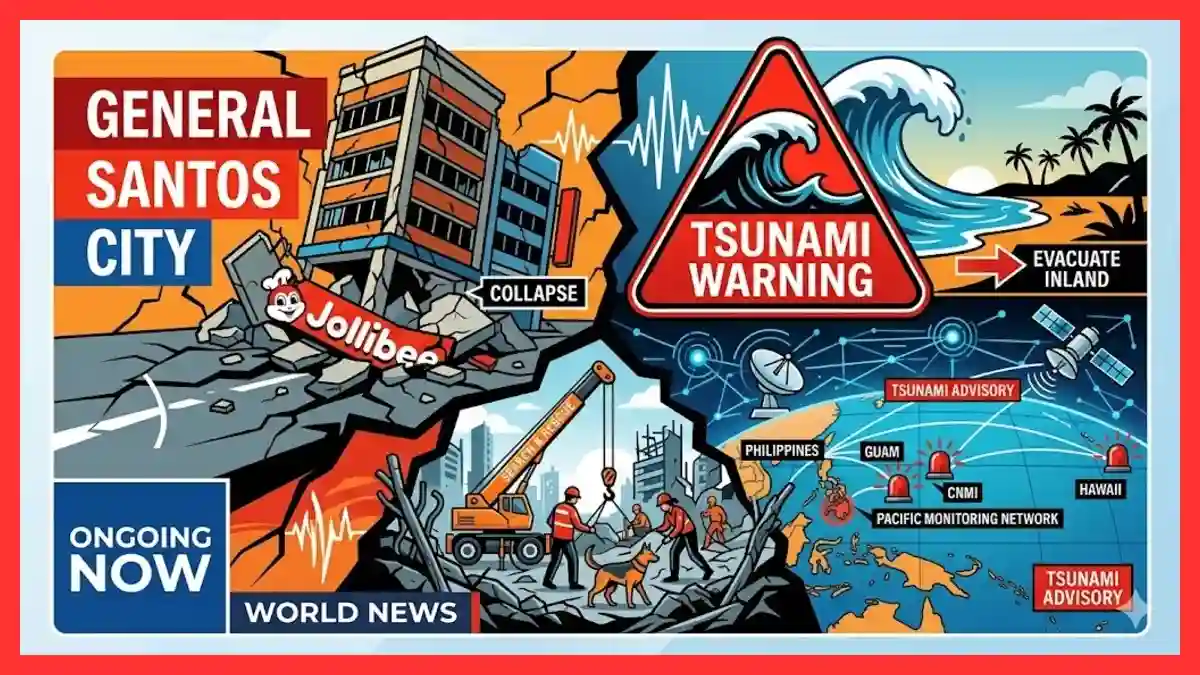
GENERAL SANTOS, PHILIPPINES — A powerful 7.8-magnitude earthquake struck off the coast of the southern Philippines early Monday, collapsing critical commercial infrastructure, claiming multiple lives, and triggering widespread tsunami warnings across the western Pacific Ocean. The offshore seismic event, which occurred at 7:37 a.m. local time, has placed municipal resilience and regional early-warning systems under immediate international scrutiny.
The Mindanao seismic event impact has reverberated far beyond its epicenter near General Santos City, exposing deep structural vulnerabilities in dense urban centers while testing the coordinated disaster frameworks of multiple Pacific territories. Municipal authorities have confirmed that the severe shaking caused the catastrophic structural failure of commercial landmarks, including a prominent Jollibee fast-food restaurant and local educational facilities, resulting in multiple casualties. Simultaneously, the oceanic energy displaced by the fault movement forced the activation of a US territory tsunami advisory, setting off emergency sirens from the coastal lowlands of Mindanao to the remote naval installations of Guam and the Commonwealth of the Northern Mariana Islands (CNMI).
                           PACIFIC TSUNAMI ALERT MATRIX
   +-----------------------+-----------------------+-----------------------+
   |   Geographic Region   |  Assigned Risk Level  | Projected Wave Height |
   +-----------------------+-----------------------+-----------------------+
   | Philippines Coastlines| Tsunami Warning       | Up to 3.0 Meters      |
   | Indonesia / Malaysia  | Regional Alert        | Up to 1.0 Meter       |
   | Guam / CNMI           | Tsunami Advisory      | Less than 0.3 Meters  |
   | Hawaii / US Mainland  | No Immediate Threat   | Normal Sea Fluctuations|
   +-----------------------+-----------------------+-----------------------+
As search and rescue operations intensify amid a succession of major aftershocks—including a significant 6.1-magnitude secondary tremor recorded at a depth of 67 kilometers—the incident has ignited an international policy discussion regarding municipal engineering standards and multinational safety protocols.
Severe Structural Collapse Claims Lives in General Santos City
The physical brunt of the energy release was concentrated heavily within the urban core of General Santos City, a major economic hub of approximately 720,000 residents located just 13 kilometers northeast of the estimated epicenter. First responders and local police units swarmed multiple disaster zones where reinforced concrete structures failed to withstand the intense lateral acceleration forces.
Among the most visible structural failures was the total Jollibee General Santos collapse, a multi-story commercial outlet that was reduced to compressed rubble within seconds of the initial tremor. Eyewitness cell phone footage authenticated by international news agencies captured the final moments of the collapse, accompanied by the screams of bystanders fleeing the falling debris.
Master Sergeant Robert Dagon of the General Santos City Police Department confirmed the immediate deployment of tactical units to the location. “Many buildings were affected, but I cannot fully enumerate them now because our teams are entirely consumed with ongoing rescue operations inside the collapsed perimeters,” Dagon stated during an emergency press briefing.
Beyond commercial properties, educational infrastructure suffered critical damage, with at least one major building on a local school campus crumpling completely. The rapid timing of the morning disaster meant that many structural environments were already occupied by civilian workers and early-morning patrons, compounding the immediate hazards.
Analyzing the Multi-Point Impact of the Mindanao Seismic Event
A technical assessment of the Mindanao seismic event impact reveals an intersection of shallow crustal displacement and vulnerable civil engineering. According to the Philippine Institute of Volcanology and Seismology (PHIVOLCS), the main shock registered an extraordinary 7.8-magnitude, centered at a nominal depth of 10 kilometers. However, indicating the inherent complexities of rapid telemetry processing, the United States Geological Survey (USGS) calculated the initial depth at 55 kilometers.
This variance in early scientific assessments is characteristic of massive ocean-trench ruptures, where tectonic slippage along complex fault lines can distribute energy across broad vertical gradients. The violent shaking triggered immediate regional blackouts, severing the high-voltage electrical grid across multiple provinces and severely hampering the initial phase of the civil defense response.
“We are dealing with a highly volatile tectonic sequence,” remarked PHIVOLCS Director Teresito Bacolcol. “The primary earthquake has already destabilized compromised soil formations and compromised urban foundations, making the secondary aftershocks exceptionally hazardous to remaining structures.”
The broader regional impact extended southward across the maritime borders of the Celebes Sea. Residents in Indonesia’s North Sulawesi and North Maluku provinces reported sustained, terrifying ground movements that caused communities to flee low-lying coastal zones in anticipation of ocean anomalies.
                       CHRONOLOGY OF SECONDS: JUNE 8, 2026
  [07:37 AM] ---------------------------------------------------- Main Shock
               A 7.8-magnitude undersea earthquake ruptures near General Santos.
  [07:44 AM] --------------------------------------------- Regional Evacuation
               PHIVOLCS issues an urgent order for coastal residents to move inland.
  [08:09 AM] -------------------------------------------- US Territory Advisory
               The US Tsunami Warning System places Guam and CNMI under advisory.
  [09:40 AM] --------------------------------------------------- Aftershock
               A powerful 6.1-magnitude aftershock strikes Sarangani Province.
Trans-Pacific Tsunami Monitoring and Advisory Allocations
The massive displacement of seawater generated by the offshore fault line triggered immediate automated responses across the global maritime monitoring framework. Within minutes of the seismic rupture, the Pacific Tsunami Warning Center (PTWC) in Honolulu, Hawaii, published deep-ocean model forecasts projecting dangerous marine surges.
The most critical threat vector developed along the immediate domestic coastlines of the southern Philippines, where ocean waves up to 3.0 meters (10 feet) above normal tide levels were projected. This prompted PHIVOLCS to issue immediate domestic maritime alerts. “We strongly advise all people living near coastal areas to evacuate immediately to higher ground or move significantly further inland,” urged Director Bacolcol.
Further out in the Pacific basin, the Guam tsunami warning system was triggered to verify incoming deep-ocean data. At 6:09 AM Chamorro Standard Time, federal authorities issued a formal US territory tsunami advisory covering both Guam and the Commonwealth of the Northern Mariana Islands (CNMI). Local civil defense offices deployed emergency personnel to monitor low-lying tourist sectors and industrial shipping berths, warning the public to stay out of the water due to anticipated strong currents and unpredictable sea-level fluctuations.
Concurrently, oceanographers completed a Hawaii tsunami risk assessment to evaluate the threat to the broader Hawaiian archipelago and the western coastline of the United States mainland. Following rigorous hydroacoustic data evaluation, the PTWC confirmed that there was no destructive tsunami threat to Hawaii, mitigating fears of a wider trans-oceanic catastrophe.
Evaluating the Mindanao Earthquake Casualties and Damage Metrics
The true scale of the human toll remains fluid as heavy lifting equipment slowly clears heavy structural columns from compressed building floors. Initial police and municipal hospital tallies verified that at least three individuals were confirmed dead in the immediate aftermath of the General Santos building collapse zones, with dozens of others treated for traumatic crush injuries, severe lacerations, and acute shock.
                  PRELIMINARY URBAN AND HUMAN IMPACT COUNTS
  +---------------------------------------+----------------------------------+
  |            Impact Category            |    Verified Metric / Assessment  |
  +---------------------------------------+----------------------------------+
  | Confirmed Fatalities                  | 3 individuals (under verification|
  | Major Commercial Collapses            | Jollibee Outlet / School Facility|
  | Primary Regional Blackouts            | 3 Provinces affected             |
  | Critical Aftershocks (Above M6.0)     | 1 registered (Magnitude 6.1)     |
  +---------------------------------------+----------------------------------+
  Caveat: Data compiled from initial police and provincial disaster response briefs.
  Figures are subject to change as rescue operations penetrate deeper into debris.
The demographic reality of the disaster underscores the vulnerability of everyday workers, service employees, and commuting students. In the commercial districts, rescue personnel worked with specialized acoustic listening devices to detect signs of life beneath pancake-collapsed concrete floors. Civil defense workers expressed grave concerns that the official casualty list would rise as rural coastal communities, currently cut off by severed telecommunication links and minor localized landslides, gradually restore contact with regional emergency commands.
Comparative Geopolitical Analysis: Systemic Infrastructure Challenges
The catastrophic damage to commercial buildings in General Santos City highlights long-standing historical challenges regarding enforcement of the National Building Code of the Philippines. When compared to previous regional disasters—such as the November 2023 Mindanao earthquake, which measured 6.7-magnitude and killed 11 people while damaging nearly 9,000 homes—the current structural failures reveal a persistent gap between regulatory theory and urban construction reality.
Historically, rapid urban growth in mid-sized East Asian cities has outpaced strict engineering compliance. Many commercial buildings undergo successive renovations that alter their load-bearing characteristics without corresponding seismic reinforcement. The failure of relatively modern retail structures during this event raises serious questions about municipal inspection corruption, material quality control, and the resilience of urban spaces situated directly over major tectonic subduction zones like the Cotabato Trench.
Furthermore, the operational reliance on international aid channels during past crises emphasizes the importance of swift diplomatic coordination. The Philippines disaster response framework, while highly experienced in typhoon management, faces distinct logistical bottlenecks when handling simultaneous urban structural rescues and widespread coastal evacuations across multiple separated islands.
Analysis: The Imperative for Transnational Disaster Logistics
This latest disaster demonstrates that local seismic events carry immediate transnational geopolitical implications. The rapid engagement of the Guam tsunami warning system and the subsequent Northern Mariana Islands tsunami threat management show how integrated American military and civilian assets in the Pacific are linked directly to the geological realities of Southeast Asia.
        STRUCTURAL FAILURE PATHWAY IN MODERN REGIONAL URBAN CENTERS

  [Rapid Urbanization] ──> [Inadequate Code Enforcement] ──> [Structural Load Stress]
                                                                     │
  [Catastrophic Collapse] <── [7.8-Magnitude Acceleration] <──────────┘
For international observers, the strategic lesson is clear: disaster mitigation requires systemic cross-border investments. While the Hawaii tsunami risk assessment successfully prevented unnecessary panic on the American mainland, the high vulnerability of coastal populations in the Philippines and Indonesia demonstrates an urgent need for enhanced international aid allocations. These funds must be targeted not merely toward short-term post-disaster recovery, but toward long-term structural engineering retrofits and the hard fortification of vulnerable civic infrastructure.
Stay sharp with Ongoing Now!
Source and Data Limitations: This geopolitical and structural report is constructed using verified real-time dispatches from the Associated Press (AP), Agence France-Presse (AFP), Reuters, the United States Geological Survey (USGS), and the Philippine Institute of Volcanology and Seismology (PHIVOLCS) issued on June 8, 2026. Because this event is actively unfolding, official casualty counts, structural damage summaries, and tsunami wave metrics are subject to logistical reporting delays. Initial data from municipal authorities in General Santos City may change as communications are re-established with isolated coastal municipalities. Speculative social media claims regarding unverified structural failures or predictive aftershock timelines have been intentionally omitted from this analysis to preserve strict journalistic integrity.